EarthCARE will unveil relationship between clouds, aerosols, and radiation
ESA's new Earth Observation mission EarthCARE involves the participation of the Remote Sensing Laboratory at the University of Évora in the validation of one of the satellite's instruments. The mission was successfully launched.
Piece by piece, the climate puzzle is being assembled. Over time, we learn more about the complex conditions and atmospheric phenomena. However, there is still a need to understand how clouds and aerosols affect Earth’s energy balance—a particularly important issue in the face of climate change. This is the goal of the new EarthCARE satellite (Earth Cloud Aerosol and Radiation Explorer), developed by the European Space Agency (ESA) and the Japan Aerospace Exploration Agency (JAXA), which was launched this Wednesday, May 29, aboard SpaceX’s Falcon 9.
“This mission was developed as part of ESA’s Earth Observation programs in collaboration with JAXA, which developed one of the four instruments on board the satellite, showcasing the excellence of European technology. It demonstrates how Space enables us to advance knowledge about our planet by collecting information on a scale that would otherwise be impossible,” says Carolina Sá, Earth Observation Program Manager at the Portuguese Space Agency.
© European Space Agency
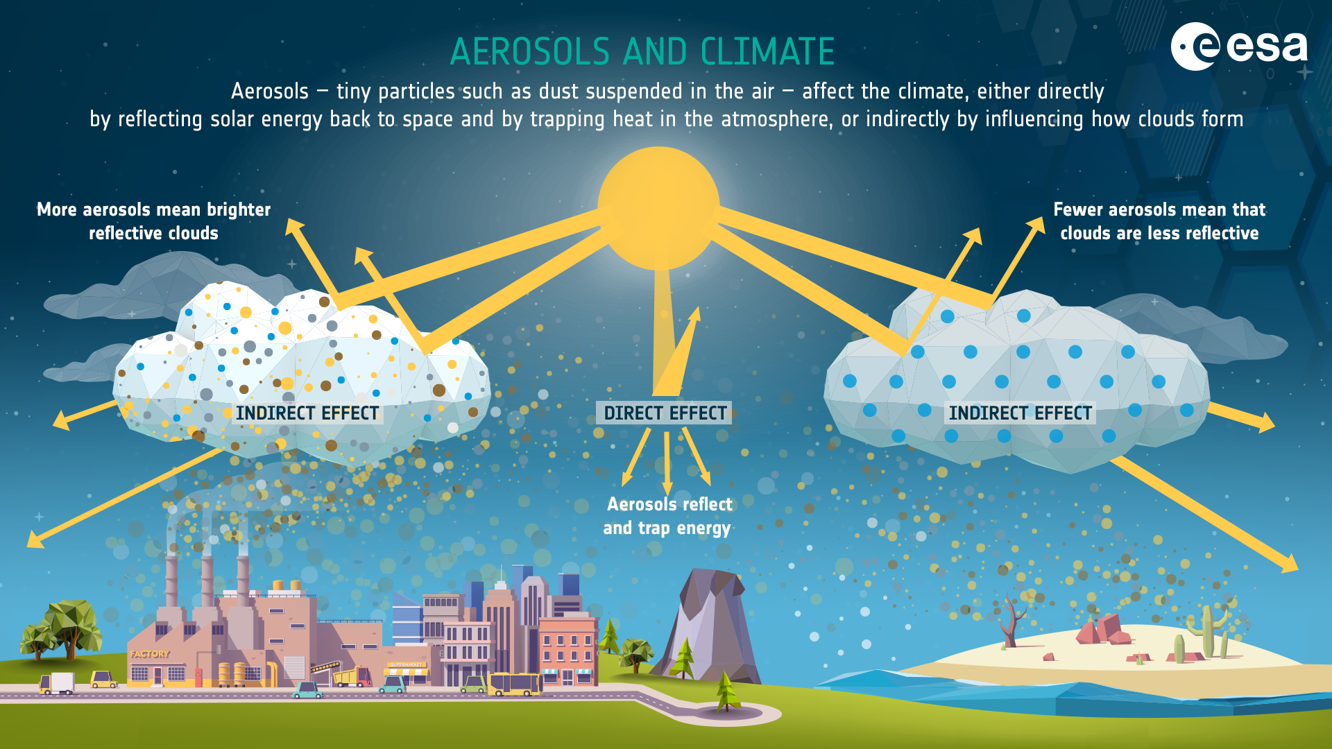
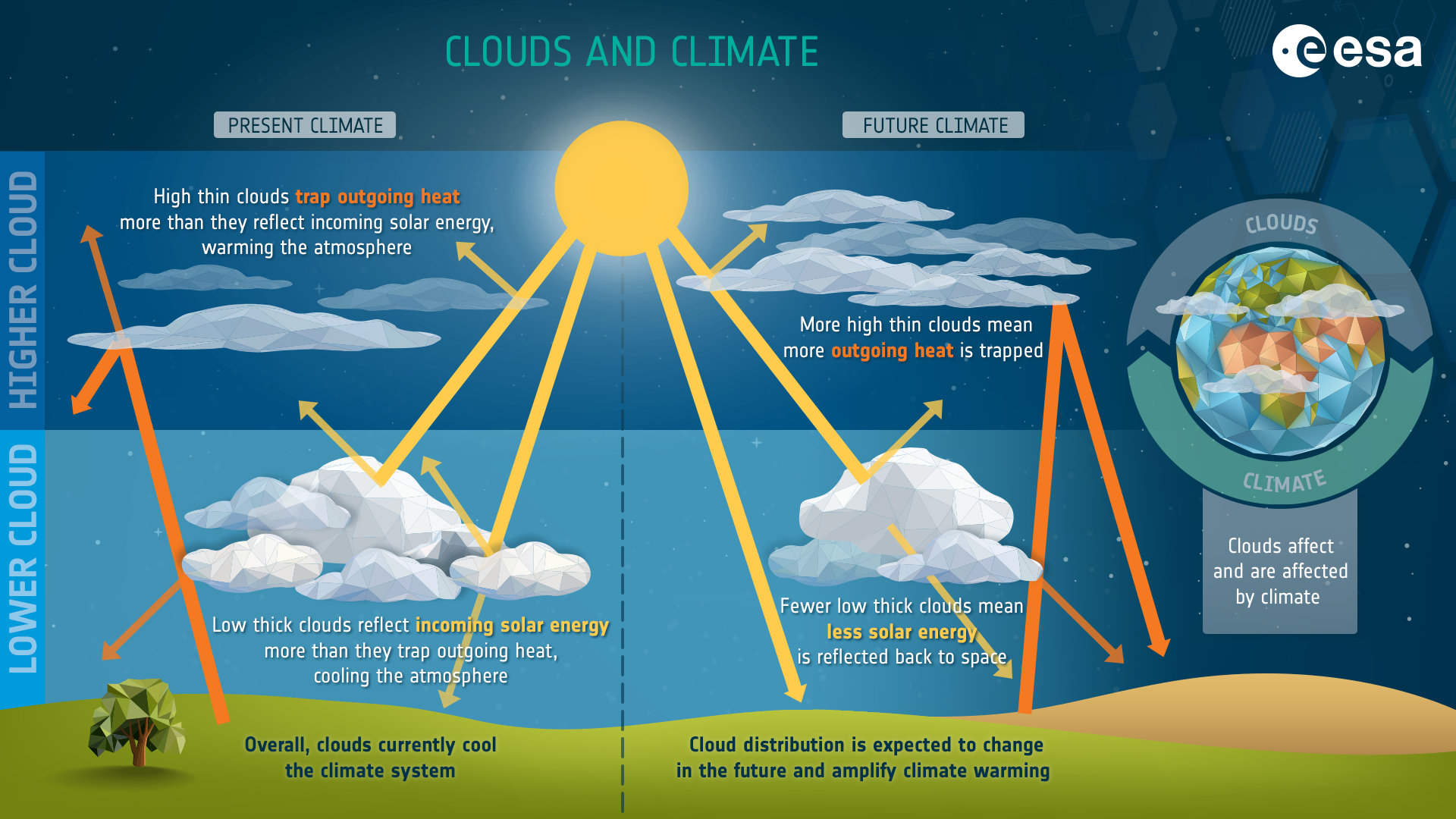
The mission, the sixth in ESA’s Earth Explorer program, will help decode the dynamics “between clouds, aerosols, and radiation,” as well as the “feedback mechanisms” between these and Earth’s surface temperature, explains Maria João Costa, a professor at the University of Évora and director of EaRSLab (Remote Sensing Laboratory), which is involved in a project to validate products from one of EarthCARE’s instruments. The laboratory “has a strong research component in atmospheric remote sensing,” focusing precisely on “understanding the radiative effects of aerosols and clouds on climate.”
The Évora laboratory is involved in the validation of the Atmospheric LIDAR (ATLID), EarthCARE’s instrument that, using laser measurements, will allow the satellite to provide “vertical profiles of aerosols and thin clouds.” This work includes the participation of ACTRIS (Aerosol, Clouds and Trace Gases Research Infrastructure) stations, which are part of the European Research Infrastructure Consortium (ERIC).
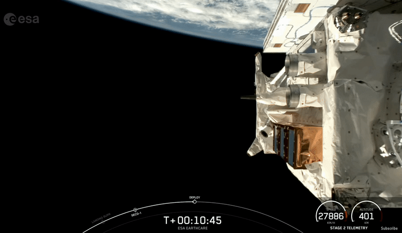
Ten minutes after liftoff, EarthCARE separated from the rocket. © SpaceX
The satellite also includes the Cloud Profiling Radar (CPR), which will perform “vertical profile measurements of clouds and vertical velocities of cloud particles.” With ATLID and CPR, the Multispectral Imager (MSI) will provide three-dimensional information with “images of clouds and aerosols in the visible, near-infrared, and thermal infrared spectral regions.” Finally, EarthCARE features a Broadband Radiometer (BBR) that will “measure reflected solar radiation and emitted infrared radiation,” explains the university professor.
Together, the four instruments will provide a clear view of the “vertical distribution of aerosols and cloud particles, as well as the velocities of droplets/particles that make up the clouds, along with Earth’s radiative balance, something that has never been fully observed together before,” adds Maria João Costa.
© European Space Agency
EarthCARE “will improve the representation of atmospheric processes in weather forecasting, climate, and Earth system models.” With more refined climate and weather projections, decisions about “mitigation strategies and adaptation measures to climate change” will be better informed. This improvement also represents a “significant impact on risk prevention,” as the available information can be “converted into timely alerts issued by authorities.”
At EaRSLab, there is anticipation and excitement about the future use of data from this new satellite, which will provide “valuable information” that will not only facilitate the implementation of mitigation and adaptation strategies to climate change but also empower us to face these challenges more effectively. And as Maria João Costa summarizes, this is an “opportunity to extend the frontier of knowledge” to solve the climate change puzzle.
