Have you seen rubbish in the sea? Take a photo, SMART will take care of the rest
The application was created under the SMART project, the winner of the first edition of the AI Moonshot Challenge promoted by the Portuguese Space Agency. Developed by a consortium that brings together members of several universities and national research centres, this is a valuable ally in the fight against marine pollution.
What if you could contribute to the fight against ocean pollution from your mobile phone? You can play an active role in this cause with SMART, an application for mobile phones with a Portuguese signature. How? When you find rubbish in the sea, photograph the debris. The application not only registers its geolocation, but also allows you to easily record some of its characteristics: size, predominant colour and accumulation area. By using the app, you will contribute to creating a European reference repository essential to train algorithms to detect this debris from Space, and develop a tool to monitor plastic pollution in the oceans.
This application was created by the SMART consortium, which, in 2020, won the first edition of the AI Moonshot Challenge. That year, the Portuguese Space Agency’s initiative sought ideas that would make a difference in the fight against ocean pollution, with solutions that joined the space technologies opportunities to Artificial Intelligence. The SMART consortium is formed by members of the Centre for Natural Resources and Environment (CERENA) of the Instituto Superior Técnico, the Underwater Systems and Technologies Laboratory from the Faculty of Engineering of the University of Porto, the University of Aveiro, the Hydrographic Institute and the MIT Portugal programme.
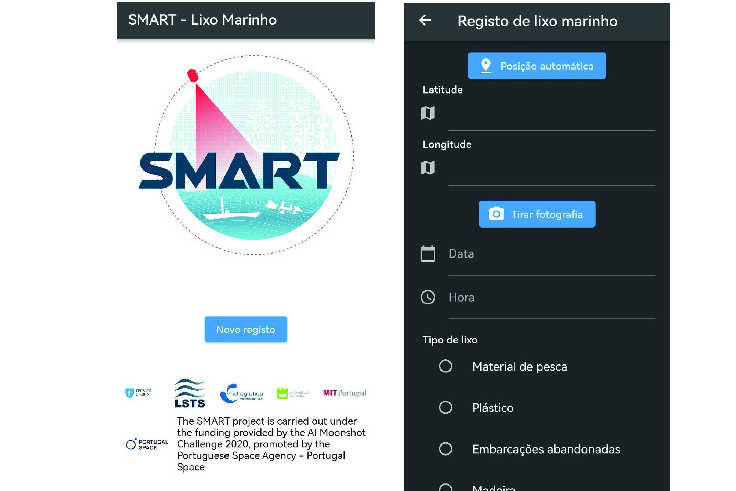
The application allows easy identification and information about the rubbish found in the sea. © DR
The idea for this solution “arose from the need to validate the plastic accumulations predicted by machine learning algorithms using in situ observations”. “For this task, we relied on the support of the Hydrographic Institute. Initially, we used physical, paper-based observation sheets. However, we quickly realised that we could expand this concept more comprehensively. This is how the idea of the mobile application came about, as a solution to this need”, explains Leonardo Azevedo, coordinator of the SMART project and one of those responsible for developing the application.
The constant search for solutions to this problem, which is not new, ultimately reveals its seriousness. In just 15 years, the concentration of plastics in the marine environment has increased ten times. The conclusion is from an article published by PLOS ONE last March. According to the report, in 2005 there were already 16 billion plastic particles on the surface of the Earth’s oceans, equivalent to 220,00 tons; in 2019, the number of fragments rose to 171 billion, or 2.3 million tons.
Leonardo Azevedo, also a researcher and lecturer at the Instituto Superior Técnico, believes that the AI Moonshot Challenge “was a unique opportunity to address a problem of extreme importance in our society,” since it awarded “a project that aims to contribute scientifically and produce results with practical impact”.
Fighting pollution can be easy
With “practical impact”, Leonardo Azevedo mentions the ease with which anyone can share information about the state of the ocean with those who, like him, study it. Behind the application is a team that, in this way, facilitates the “modelling of the temporal and spatial evolution of plastic accumulations on the ocean surface”. How? “Different deep learning methods are used in a complementary way. On the one hand, these methods are employed to automatically identify the areas where these accumulations occur, through the automatic identification of satellite images, such as those from Sentinel-2, in this current phase of the project.”
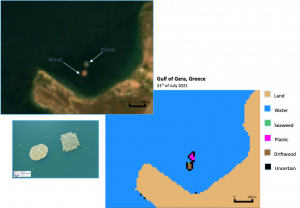
Sentinel-2 helps in the automatic identification of rubbish accumulations. © DR
At the same time, the team uses “approaches to rapidly calculate the spatiotemporal evolution of the ocean, which is a complex problem that usually requires high computing power and expertise”. “To calibrate and validate the proposed model, we take advantage of regular campaigns carried out by the Hydrographic Institute with ships, as well as data obtained by non-traditional means, such as autonomous vehicles,” he adds. And now, with the creation of the application, they have significantly widened the information base as any other scientists and citizens can contribute. The purpose of the SMART creators is to make public the data shared by the users and for these to converge “with a European reference repository for this type of identification”. They will be supported in this by the Portuguese Space Agency and the European Space Agency.
At the moment, Smartapp is only available for Android, but Leonardo Azevedo says that the team is “actively working to make it available”, very soon, on the iOS platform. And it will be very intuitive and uncomplicated in both operating systems: “The goal is that the application is easy to use, keeping a simple design and a reduced number of options. After installing the application on your mobile phone, the user will be able to start using it immediately.”
For now, and “after 12 months of the project”, the results, which the team is sharing with the scientific community through “publications in international journals and presenting them in various scientific dissemination events”, have been “exciting and promising”. “We are on the right track”, he believes, adding that “the collaboration of the Portuguese Space Agency has been extremely valuable”, as well as “the connection and collaboration established with ESA”.
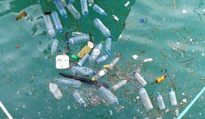
Over the course of 15 years, the amount of plastics in the ocean has increased by a factor of ten. DR.
In addition to creating the app, the SMART project developed “a method for automatically identifying accumulations of marine debris, such as plastic and wood, from satellite images”. Tested in different regions of the globe, the model uses data from the constellation Sentinel-2, of Copernicus, the European Union’s Earth Observation Programme, and has obtained “relatively positive results”. Moreover, “the numerical modelling component of the hydrodynamics of the study area has already been implemented and validated”.
Currently, the team is starting “work to develop a new computational tool for the spatiotemporal modelling of the ocean, which is one of the essential components to achieve the ultimate goal of the project”: the automatic identification of accumulations and the hydrodynamic conditions of the ocean, which will allow inferring about the origin and destiny of these accumulations.
The project members are also focused on the first version of the application and its dissemination. “In the next app version, we will integrate user feedback and comments to enhance its functionality and usability further. In addition, we are trying to integrate the app platform with OceanScan, a mature project funded by ESA, ” he says.
With a positive future ahead, the SMART consortium says it is “committed to continuing to advance research, strengthen partnerships and make a positive contribution to the fight against ocean pollution”. So don’t forget: next time you go to the beach, take your towel, sun cream and SMART with you.
