Look up: the solution to (almost) everything on Earth may lie in the satellites
These days, we can decide whether or not to leave home with an umbrella - and we can thank Earth observation technologies for the large part of this. Acting on several fronts, satellites inform us about the weather, the fields we cultivate, the roads we travel or even the quality of the water we drink. And they have been gaining more and more space in various sectors.
On 15 January, the world watched an undersea volcano near the Pacific islands of Tonga explode in a violent eruption, causing a tsunami that hit not just Tonga but countries as far away as Chile, at a distance of almost 10,000 kilometres. Satellites captured and recorded images of the eruption.
Days later, a BBC article explained the importance of these images, and this “fleet” that observes the Earth from space. Some geostationary satellites are pointed constantly at certain regions of the planet, which means that “the data is immediately available for study” in cases like the Hunga-Tonga-Hunga-Ha’apa explosion. On the other hand, there are satellites in lower orbits that make follow-up observations, which help to understand the consequences of such natural disasters. Looking from the front, it is difficult to see what is going on beyond all the dust, ash, gasses and smoke that have climbed from the volcano into the sky, reaching 20 kilometers high. However, satellites allow observers to look through that thick cloud and see the devastation that the explosion has caused. Some of the satellites in the Sentinel family of the Copernicus programme – that is, the European Union’s Earth observation programme – have the on-board radar technology necessary for such images to be seen.
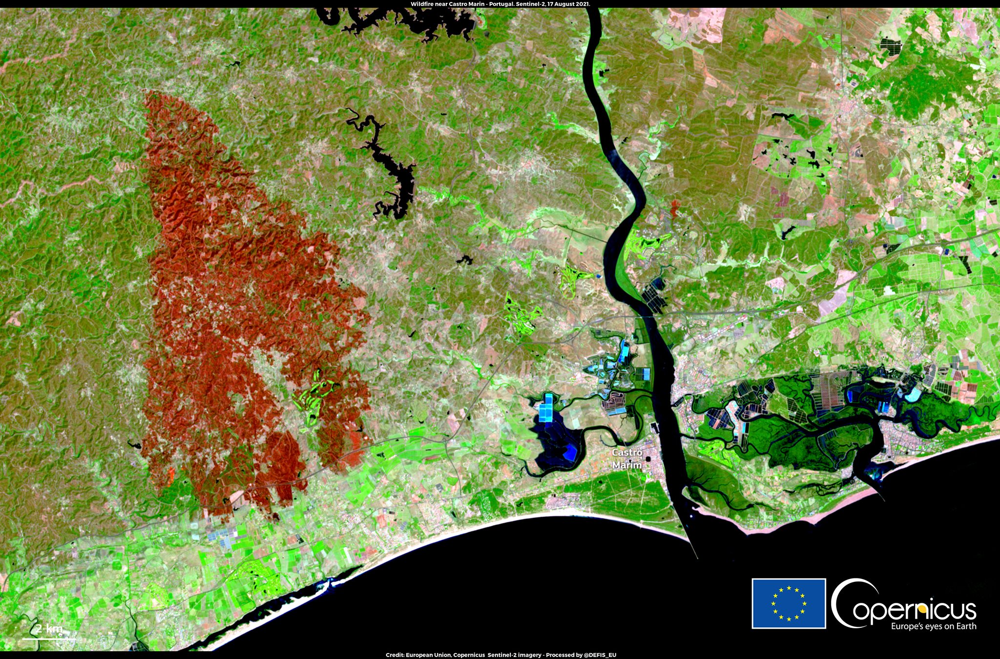 Castro Marim fires (Summer 2021) seen from above by Sentinel-2, one of the satellites of the European Earth Observation programme, Copernicus. ©Copernicus
The eyes of the world are turning more and more toward these types of phenomena. The images from space help us to understand the dimension of these catastrophes, and also help the preparation of search and rescue responses.
This was the case, for example, during the Castro Marim fire in the summer of 2021. The Portuguese Civil Protection activated the Copernicus Emergency Management Service (CEMS) to monitor the fire via satellite. Through rapid mapping, Copernicus provided key information to identify and assess the most affected locations, the extent and intensity of the fires, and the severity of the damage resulting from them.
Should you take the umbrella or not?
As important as they are, these are not, however, the only capabilities of Earth observation services. “Data collected by satellites has a wide range of applications, and is also essential in weather forecasting, forest and agricultural resource management or infrastructure monitoring, for example. And we all already use this technology in our daily lives. Nobody leaves home without checking the weather forecast on their mobile phone. Nowadays these forecasts allow us to decide quite safely whether to leave home with or without an umbrella, without running too many risks that we’ll get wet. This improvement in forecasts is largely due to data from meteorological satellites of the European Organisation for the Exploitation of Meteorological Satellites (EUMETSAT)”, recalls Carolina Sá, responsible for Earth Observation projects at the Portuguese Space Agency.
Regarding the state of the weather in Portugal, the Portuguese Institute of Sea and Atmosphere (IPMA) uses this type of data to increase the precision and accuracy of its forecasts. But IPMA’s use of satellite data is not limited to weather forecasting: the national meteorological, seismic and oceanographic service “accumulates skills in weather forecasting, meteorology, surveillance, climate monitoring” and, of course, “monitoring the environmental conditions of the sea”, explains IPMA’s Earth Observation coordinator, Isabel Trigo.
She goes on to emphasize that the service’s team uses “very diverse” data and “different platforms” to “monitor what happens in various areas very frequently”, since “meteorological surveillance has to have a very high cadence of Earth observation”. Translated into figures, we are talking about “frequencies between 15 minutes, or for the smaller regions that include Europe, every five minutes”. This surveillance makes it possible to quickly identify “extreme situations”, such as high precipitation or strong winds, which in practice protects the population from adverse and/or extreme weather situations.
The last few decades have seen an “improvement in the forecasts”, which goes hand in hand with greater efficiency of “weather prediction models”. In other words, the increase in the quantity and quality of data has made it possible to study “meteorological phenomena on increasingly fine scales”, Isabel Trigo points out.
Moreover, Earth observation services are key tools when it comes to making increasingly important decisions. “The Copernicus Climate Change Monitoring Service (C3S) gives us access to information about the climate in the past, present, and future, in Europe and beyond. And it is this data that helps the European Union to define better climate change adaptation and mitigation strategies and to monitor the impact of its political decisions”, explains Carolina Sá. On the other hand, the Copernicus Atmosphere Monitoring Service (CAMS) “provides continuous data and information on the composition of the atmosphere, which is useful in various domains, supporting applications in the areas of health, environmental monitoring, renewable energies, meteorology, and climatology”.
From space to the countryside
Arlindo Santos, Deputy for Knowledge and Innovation at the Agency for Integrated Management of Rural Fires (AGIF), stresses the importance of space technologies for the agroforestry sector: this could “be a way to attract new people, with differentiated skills, to a sector that is far from the minds of the younger generation, with a few exceptions”. Although the use of satellites is less obvious – or at least more recent – in these areas, there are those in Portugal who are already using the potential of Earth Observation services to improve agricultural efficiency, for example.
This is one of the missions of Agroinsider, which also aims to “promote environmental sustainability” through agriculture, because “a carbon-neutral world generates positive agriculture”. How does this Evora-based company use Earth Observation data to that end?
“What we do is use Earth Observation sensors to measure parameters that are important from the point of view of vegetative growth and soil quality,” introduces the company’s CEO, José Rafael Silva. Sentinel-2’s optical sensor gives farmers access to data such as “vegetation texture”, “photosynthetic activity” and surface water quality. Sentinel-1’s radar allows a better knowledge of “the structure of the vegetation”, distinguishing trees through data on their leaves, and gathering information on “the number of branches, their height, and opacity”. Besides this, the satellite “can be used to study the quality of the soil, understanding if the soil is sandy or clayey” and to “know if the tree has growing difficulties or not”.
“To the user of our services, we reduce the stress and tension that some decision-making entails,” he explains. With the data collected by Agroinsider, the farmer knows precisely which area could be negatively affected, avoiding “long travel campaigns” that would be necessary for workers to carry out on-site monitoring. Both parties win, and so does the planet: “We automate this process and cut, for example, the fuel spent and the hours of surveillance”. And this also allows the end consumer to buy “cheaper and more sustainable products”.
 Earth Observation technologies are more and more present in the agroforestry sector. © ESA
Satellites are particularly important when we talk about living, constantly changing raw materials, as is the case with forests, for example. Therefore, the data collected can also help entrepreneurs in the paper industry to better understand the forest and make important decisions. This data, along with algorithms generated by Artificial Intelligence, is the basis of a pioneering project that unites CELPA – Paper Industry Association and Tesselo, a start-up working in the area of environmental sustainability, to meet the needs of the Portuguese paper industry, helping in the surveillance of growth, but also of fires and pests.
This is even one of the satellites’ greatest contributions to fire and forest management, as AGIF’s Arlindo Santos pointed out: it is expected that “in the near future” Earth Observation technologies “will gain an even greater prominence, significantly improving the efficiency of the entire process chain” of the Integrated Rural Fire Management System (SIGFR).
Watching Earth and water
These technologies are also gaining ground in the liquid state, addressing and solving problems that plague our oceans and coastal areas, which correspond to more than 70% of the area of our planet. This is the case of the Habtrail project, from the Azorean company Eyecon Group, which recently won the Portugal Space Atlantic Challenge.
The project aims to develop a tool to combat the proliferation of harmful algae, which affect not only Portuguese waters, but all coastal areas in the world. Eyecon Group has developed two deep learning models. Considering the impact of this type of algae on aquaculture, fishing, tourism, and public health, Habtrail can become a good ally of maritime activity and the Blue economy.
Knowing the status of water bodies is imperative. according to the European Commission, about “15% of EU surface water bodies are in an unknown ecological status” and “about 40% in an unknown chemical status”, as read in a 2018 article in Environmental Management: The Transition of EU Water Policy Towards the Water Framework Directive’s Integrated River Basin Management Paradigm, by Theodoros Giakoumis and Nikolaos Voulvoulis.
Theodoros Giakoumis and Nikolaos Voulvoulis reported in the 2018 article “Environmental Management: The Transition of EU Water Policy Towards the Water Framework Directive’s Integrated River Basin Management Paradigm” that, according to the European Commission, about “15% of EU surface water bodies are in an unknown ecological status” and “about 40% in an unknown chemical status.”
The same information can be found on the Undersee website. This Coimbra startup developed the first Portuguese FerryBox system, which can “anticipate the phenomenon of algae bloom [harmful algae]” and protect production in aquaculture, thus making it “more sustainable”, explains Jorge Alexandre Vieira, CEO of Undersee. “We use Earth Observation technologies, as well as forecasting models from CMEMS [Copernicus Marine Environment Monitoring Service]. And we combine it with in situ monitoring, which we put on boats. That’s the ferrybox system,” he explains.
The constant demand for consumption, the increase in the world population, and the fact that the planet is increasingly subject to climate change may compromise the consumption of protein-rich food, 16% of which comes from the oceans. The system developed by Undersee wants to respond to this problem, mainly in aquaculture: “The system allows us to anticipate these natural phenomena, protect the production and assure that, in the future, there is no loss due to the state of the water quality.”
 Nowadays, satellites provide data to evaluate water quality. ©ESA
Satellites on the way
It is not too far-fetched to say that everything mentioned above, from natural phenomena to vegetation monitoring, also affects, in a certain way, the infrastructures that get us where we want to go. Earth Observation technologies have made their mark in this field. One such example is Spotlite, a start-up from Coimbra that developed “a platform to monitor risks that may affect different infrastructures”.
“Right now we are focused on these areas: geo-risks, vegetation, floods, and other anthropic risks”, explains Spotlite’s CEO, Ricardo Cabral. In the first case, for example, the platform uses this data to monitor “soil stability”. It evaluates whether vegetation presents “any risk for the circulation on roads or railways”. The same approach is applied in the case of floods, but Spotlite’s work focuses “more on sending early warnings with meteorological data,” so that service can be interrupted in a situation of high risks – such as a flood zone where a train passes, for example. As for risks caused by human activities, the startup monitors “deforestation and agricultural activities”.
Diagnostics and alerts aim to avoid critical infrastructure failures, by facilitating early interventions. “The aim is precisely to use high-frequency monitoring over quite extensive areas so that infrastructures are always evaluated”. And what state are the Portuguese railways or motorways in, for example? “It is very easy to think that these infrastructures were built 30, 40, or 50 years ago and, in most cases, they are approaching their life limit,” warns Ricardo Cabral. “This causes problems for maintenance managers because it is a life span that is being extended and that entails more studies and more work,” he adds. Improving maintenance activities is also the goal of Spotlite, whose CEO believes that, “tendentially, field operations and inspections will gradually be replaced by remote monitoring”.
“For these and many other reasons, Earth Observation from space is so important. We live on a planet that is degrading very quickly due to human activity, and we must take care of it so that we can leave our children a home where they can live as we do. Satellite data helps us in this mission and the Portuguese Space Agency is increasingly betting on this technology to boost this area in Portugal,” says Hugo André Costa, director of the Portuguese Space Agency.
And the expansion of Earth Observation technologies contributes to this, as well as to the data being “increasingly accessible and adequate”. In all aspects – from the sea that bathes the land to the road that takes us to the countryside, passing through the forest that we can see from the train window.
